A contractor we worked with on a mid-rise project off Del Prado Boulevard encountered groundwater at just four feet below grade, turning a routine excavation into a logistical puzzle. Cape Coral's extensive canal network, with over 400 miles of waterways, keeps the surficial aquifer exceptionally high and reacts almost instantly to tidal fluctuations. This reality forces a different approach: the deep excavation design must integrate solid dewatering, soil mixing, or secant pile walls from the first sketch. The local geology is dominated by the Fort Thompson Formation, a sequence of sandy limestone, shell beds, and loose quartz sand, where open-graded layers can collapse under seepage forces. Without a site-specific geotechnical model calibrated to ASTM D1586 and ASTM D2487 data, you risk face instabilities, bottom heave, and damage to adjacent waterfront structures, a risk no developer in this booming Lee County corridor should accept.
In Cape Coral, controlling groundwater during excavation is not a dewatering afterthought: it is the primary structural design parameter.
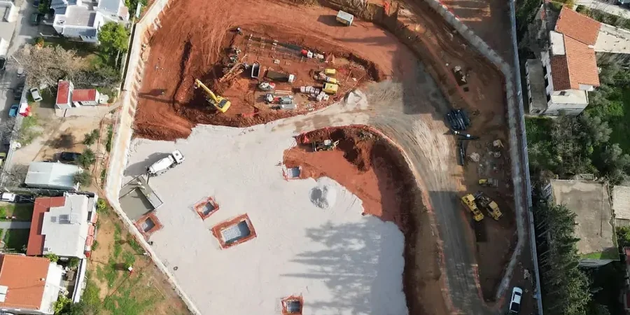
Scope of work in Cape Coral
Working video
Typical technical challenges in Cape Coral
The subtropical climate of Southwest Florida exposes deep excavations to concentrated summer storms that can deliver three inches of rain in an hour, overwhelming sump pumps and destabilizing unsupported faces. Our risk management protocol ties directly to the National Hurricane Center's precipitation frequency estimates for Cape Coral: we design the dewatering system for the 10-year, 24-hour storm event, routing discharge to an existing stormwater canal only after checking the city's strict backflow prevention ordinance. Overlooking a single fossiliferous shell lens, where horizontal permeability exceeds 1x10^-1 cm/s, can trigger piping erosion that undermines adjacent pavement in less than a shift. We pair vibrating wire piezometers with daily LiDAR scans of the excavation perimeter, setting threshold alerts at 0.15 inches of lateral deflection before the morning huddle, so the superintendent can adjust the bracing sequence proactively rather than reacting to a slough.
Our services
Beyond the core excavation design, we deliver integrated packages that resolve the full construction sequence, from site investigation to structural interface.
Shoring System Engineering
Complete design of cantilever and anchored soldier pile walls, sheet pile cofferdams, or tangent secant pile shafts tailored to Cape Coral's carbonate sand. Shop drawings include waler connections, corner bracing, and sequenced lagging installation notes.
Construction Dewatering Design
Hydraulic modeling in MODFLOW to size deep well and eductor systems, calculating radius of influence and predicted drawdown. We submit the SFWMD dewatering permit package with the required aquifer performance test data.
Third-Party Peer Review & Instrumentation
Independent review of contractor-submitted means and methods, including structural analysis of bracing frames. We install and monitor inclinometer casings, settlement points, and crack gauges on nearby structures, issuing weekly compliance reports.
Quick answers
What is the typical cost range for a geotechnical deep excavation design in Cape Coral?
How close to a canal can we excavate without risking slope failure?
It depends on the setback and the depth of the cut, but we typically apply a 1.5:1 influence line from the toe of the excavation. We analyze the canal bank's global stability using Spencer's method, incorporating rapid drawdown scenarios to ensure the factor of safety stays above 1.5.
Can you design a shoring system that allows us to work during the rainy season?
Yes, we design for the 10-year storm event with a redundant pump array and a sealed working platform. Our specifications include a perimeter interceptor ditch and sump layout that keeps the formation level trafficable even during a typical afternoon thunderstorm.
What laboratory tests are critical before finalizing the excavation support design?
We prioritize consolidated-undrained triaxial tests on undisturbed shelly sand specimens, grain size distribution per ASTM D6913 to assess filter compatibility, and unconfined compression on limestone cores to determine the bond strength of the cemented layers.